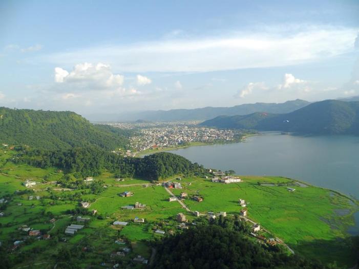
Pokhara City
Pokhara is third largest city of Nepal with an area of 55.22 km square and a population of over 300,000 inhabitants, making it the nation’s most densely populated city.The city is located approximately 200 km west of the country’s capital, Kathmandu.It serves as the headquarters of Kaski District, Gandaki Zone and the Western Development Region.Three out of the ten highest mountains in the world — Dhaulagiri, Annapurna I and Manaslu — are within 30 miles of the city.Due to its proximity to the Annapurna mountain range, the city is also a base for trekkers undertaking the Annapurna Circuit through the ACAP region of the Annapurna ranges in the Himalayas.
Pokhara is home to many Gurkha soldiers. It is the second most expensive city in the country after Kathmandu, with the Cost of Living Index of 95.
Pokhara is in the northwestern corner of the Pokhara Valley, which is a widening of the Seti Gandaki valley that lies in the midland region (Pahad) of the Himalayas. In this region the mountains rise very quickly and within 30 km, the elevation rises from 1,000 m to over 7,500 m. As a result of this sharp rise in altitude the area of Pokhara has one of the highest precipitation rates in the country (3,350 mm/year or 131 inches/year in the valley to 5600 mm/year or 222 inches/year in Lumle). Even within the city there is a noticeable difference in rainfall between the south and the north of the city, the northern part of the city situated at the foothills of the mountains experiences proportionally higher amount of precipitation. The Seti Gandaki is the main river flowing through the city. The Seti Gandaki (White River) and its tributaries have created several gorges and canyons in and around the whole city which gives intriguingly long sections of terrace features to the city and surrounding areas. These long sections of terraces are interrupted by gorges which are hundreds of meters deep. The Seti gorge runs through the whole city from north to south and then west to east and at places these gorges are only a few meters wide. In the north and south, the canyons are wider.
In the south the city borders on Phewa Tal (4.4 km2) at an elevation of about 827 m above sea level, and Lumle at 1,740 m in the north of the city touches the base of the Annapurna mountain range. 3 eight-thousand meter tall peaks (Dhaulagiri, Annapurna, Manaslu) can be seen from the city. The Machhapuchhre (Fishtail) with an elevation of 6,993 m is the closest to the city. The porous underground of the Pokhara valley favours the formation of caves and several caves can be found within the city limits. In the south of the city, a tributary of the Seti flowing out of the Phewa Lake disappears at Patale Chhango , also called Davis Falls, after someone who supposedly fell into the falls) into an underground gorge, to reappear 500 metres further south. To the south-east of Pokhara city is the municipality of Lekhnath, a recently established town in the Pokhara valley, home to Begnas Lake.